The question keeping Sammamish homeowners awake at night isn’t “if” another flood will happen. It’s “when.”
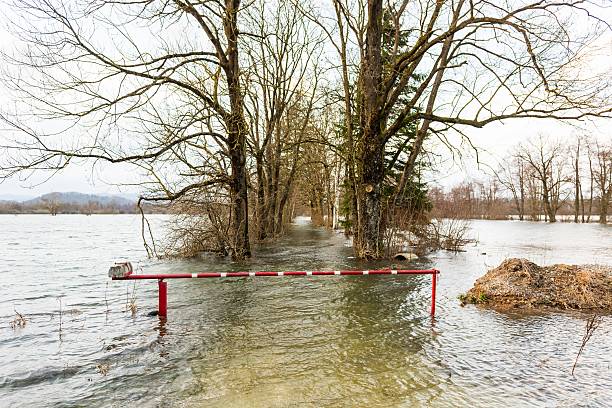
After December 2025’s catastrophic Sammamish flooding that sent Lake Sammamish waters creeping into homes, overflowed Issaquah Creek beyond recognition, and turned the Sammamish River into a raging torrent—everyone’s asking the same thing: how do we know when it’s coming next time?
Here’s what most people don’t realize: floods don’t just “happen.” They announce themselves through warning signs that—if you know what to watch for—give you hours or even days to prepare, protect your property, and potentially avoid catastrophic damage.
The December 2025 event didn’t surprise meteorologists or flood forecasters. They saw it building for days. But most homeowners didn’t know what signs to monitor or where to find critical information.
Today, that changes. I’m pulling back the curtain on the exact warning signs that predict Sammamish flooding before water reaches your property—the same indicators emergency managers and professional restoration companies monitor constantly.
Understanding Sammamish’s Flood Patterns: Why Timing Matters
Before diving into specific warning signs, let’s talk about when Sammamish flooding typically occurs and why December 2025 fit a troubling new pattern.
Historically, major flood risk peaked in spring when mountain snowmelt combined with rainfall created high river volumes. Flooding and high water are most common from October through April during periods of heavy rainfall or rapid snowmelt, with King County rivers having flooded in every month except August.
But climate change has rewritten these patterns dramatically.
Atmospheric rivers occur most often in the fall and winter in the Northwest, and these storms are becoming more frequent and intense. As the climate changes, atmospheric rivers hold more moisture, and that means more rainfall, potentially leading to major flooding in areas not prepared for intense storms.
December 2025 demonstrated this new reality. Instead of spring snowmelt flooding, we experienced winter inundation from atmospheric river events that climate models predict will become increasingly common.
The Pacific Northwest experiences about 10 to 15 atmospheric rivers annually, but their intensity is escalating. Atmospheric rivers cause about 80% of Oregon’s flooding events, and the same holds true for Western Washington.
The takeaway? Sammamish flooding risk now extends throughout fall and winter, with atmospheric rivers creating flood conditions during seasons that were historically lower risk.
Warning Sign #1: River Gauge Levels Enter “Flood Phase”
This is your most reliable, real-time warning system—and it’s completely free.
King County operates a sophisticated Flood Warning System that monitors seven major rivers and Issaquah Creek with river gauges providing real-time water level data. The purpose of the King County Flood Warning System is to warn you about rising floodwaters on major rivers so you can prepare before serious flooding occurs.
How the flood phase system works:
Rivers are assigned four flood phases based on water levels measured at specific gauge locations:
Phase 1 (Normal): River flows within normal ranges. No flood concerns.
Phase 2 (Advisory): Water levels rising. Minor flooding possible in low-lying areas. Time to start monitoring actively.
Phase 3 (Watch): Moderate flooding likely. Properties in known flood zones should prepare for possible evacuation. Roads may close.
Phase 4 (Warning): Major flooding occurring or imminent. Evacuations likely. Significant property damage expected.
In most locations, the alert system provides at least two hours lead time before floodwaters reach damaging levels.
How to monitor river phases:
Download the King County Flood Warning App to your smartphone. The app helps you stay informed about conditions on seven rivers and Issaquah Creek, with data downloaded from U.S. Geological Survey, National Weather Service, and Northwest River Forecast Center about every 10 minutes.
The app shows current river levels, flood phase status, gauge data trends and forecasts, and predictive models for the next 24-72 hours.
Sign up for free Flood Alerts at the King County website. Get Flood Alerts by email, text message, or phone call, selecting the rivers and flood phases that are of interest to you.
For Sammamish flooding concerns, monitor these specific locations:
- Lake Sammamish near Redmond (for lakeshore properties)
- Issaquah Creek at Issaquah (for creek-adjacent homes)
- Sammamish River at Bothell (for river corridor properties)
When any of these gauges enter Phase 2, start preparing. Phase 3 means take action immediately. Phase 4 means evacuate if you’re in known flood zones.
Critical numbers to save:
King County Flood Warning Center: 206-296-8200 or 800-945-9263 (24/7 during flood events)
During active flooding, call for the latest information on conditions, sandbag locations, and evacuation updates.
Warning Sign #2: Atmospheric River Forecasts Show “Strong” or “Extreme” Events
Atmospheric rivers are the primary driver of Sammamish flooding, and meteorologists can predict them days in advance.
What atmospheric rivers are:
Atmospheric rivers are large channels of water in the atmosphere that vary in size but can be 250-375 miles wide and over 1,000 miles long, with some carrying more water than the Amazon River.
Unlike physical rivers, atmospheric rivers transport water as vapor rather than liquid, with high- and low-pressure systems determining where they move.
When atmospheric rivers make landfall on the Pacific Northwest coast, they can bring moderate to heavy rainfall for two days or more—exactly the conditions that cause catastrophic flooding.
The atmospheric river intensity scale:
Atmospheric rivers are rated on a scale of 1-5 based on duration and intensity:
AR1-2 (Weak to Moderate): Beneficial rain with minimal flood risk
AR3 (Strong): Prolonged heavy rain with moderate flood potential
AR4-5 (Extreme): Catastrophic rainfall with major flood certainty
December 2025’s events involved multiple AR3 and AR4 storms hitting the region in quick succession. An early warning allowed the Washington Department of Transportation to close a highway with high avalanche danger in November 2022, demonstrating how atmospheric river forecasts enable proactive preparation.
Where to find forecasts:
The Center for Western Weather and Water Extremes at Scripps Institute provides atmospheric river forecasts and tracking.
The National Weather Service Seattle office issues watches and warnings for incoming atmospheric rivers.
Local news outlets extensively cover atmospheric river predictions when significant events are forecast.
How to interpret forecasts for Sammamish flooding:
Any AR3 or higher forecast to hit Western Washington warrants close attention. If forecasts show AR events lasting 48+ hours, Sammamish flooding becomes highly likely.
Back-to-back atmospheric rivers—like December 2025’s pattern—create especially dangerous conditions because ground saturation from the first event amplifies flooding during subsequent storms.
Warning Sign #3: Soil Saturation Reaches Critical Levels
Even moderate rainfall causes flooding when ground can’t absorb additional water.
With soils already saturated, flash flooding and rapid river rises are more likely with new bouts of rain. This is why December 2025’s flooding was so severe—weeks of rain saturated soils before the major atmospheric river events arrived.
Understanding soil saturation:
Soil acts like a sponge. Initially, it absorbs rainfall, preventing runoff. But once saturated, additional precipitation runs directly into creeks, rivers, and lakes rather than soaking into ground.
In the Pacific Northwest, fall and winter rains progressively saturate soils. By late December, ground often reaches maximum capacity, meaning any additional significant rainfall immediately triggers flooding.
How to assess saturation conditions:
Watch for these indicators around your property:
- Standing water persists in yard depressions days after rain ends
- Ground feels spongy or mushy when walked upon
- Water pools on lawns and landscaping that normally drain well
- Basement or crawl space dampness increases noticeably
- Storm drains back up during moderate rainfall
Regional indicators include:
- Weather forecasters specifically mention soil saturation in flood warnings
- Local rivers remain elevated even during dry periods between storms
- Multiple rain events occur within short timeframes (days or weeks)
The USDA Natural Resources Conservation Service provides soil moisture data for agricultural regions, offering insight into saturation levels across watersheds.
Why this matters for Sammamish flooding:
When forecasts show heavy rain approaching and soils are already saturated, flooding becomes almost inevitable. The same storm that might cause minor problems in dry conditions creates catastrophic flooding in saturated conditions.
This is why timing matters. Early winter atmospheric rivers might cause manageable flooding. But mid-to-late winter events—after months of progressive saturation—produce the worst floods.
Warning Sign #4: Multi-Day Rainfall Forecasts Exceed 4 Inches
The duration and total accumulation of rainfall matter more than instantaneous intensity.
Forecasters expect 2 to 6 inches of rain in the lowlands and 4 to 10 inches across the Olympics and Cascades by late Wednesday, on top of 1 to 4 inches that fell over the weekend. These prolonged rain events saturate watersheds completely.
Why total accumulation matters:
A brief intense downpour might cause flash flooding in urban areas but doesn’t typically trigger major river flooding. However, sustained moderate-to-heavy rain over 48-72 hours overwhelms watershed capacity, causing rivers and lakes to rise steadily to dangerous levels.
For Sammamish flooding, watch forecasts showing:
- 4+ inches total rainfall predicted over 3-5 day periods
- Rainfall rates of 0.25-0.50 inches per hour sustained for multiple hours
- Sequential storm systems with minimal dry periods between events
The National Weather Service issues specific precipitation forecasts showing projected accumulation over multiple timeframes. Pay attention to 48-hour and 72-hour totals particularly.
Elevation impacts:
Mountain rainfall translates to creek and river flooding hours later as water flows downhill. With rainfall expectations of 4 to 10 inches across the Olympics and Cascades, even if Sammamish valley receives “only” 2-3 inches, upstream accumulation creates dangerous downstream flooding.
Issaquah Creek, for example, drains substantial watershed area in the Cascade foothills. Heavy rain in those elevations inevitably produces creek flooding in Issaquah and downstream Sammamish neighborhoods regardless of local rainfall totals.
Warning Sign #5: Winter “Rain-on-Snow” Events Are Forecast
This is one of the most dangerous flood scenarios in the Pacific Northwest.
Rain-on-snow events occur when warm atmospheric rivers bring rain to areas where snowpack exists, typically elevations above 3,000-4,000 feet. The rain melts accumulated snow rapidly, releasing snowpack water volume in addition to rainfall itself.
Why rain-on-snow creates extreme flooding:
The combination of rainfall PLUS rapid snowmelt creates water volumes far exceeding rainfall alone. This overwhelms rivers and creeks quickly, producing flash flood conditions.
Snowpack acts as frozen water storage. A foot of snow might contain 1-2 inches of water equivalent. When warm rain falls on this snow, it releases all that stored water within hours rather than gradually over weeks as normal snowmelt would.
When rain-on-snow risk is highest:
Mid-winter (December-February) when significant snowpack exists but temperatures can still rise above freezing with atmospheric river warmth. Elevation zones between 3,000-6,000 feet where snow accumulation is substantial but melting is possible with temperature increases.
Monitoring for rain-on-snow threats:
The National Weather Service specifically mentions rain-on-snow potential in forecast discussions when conditions align. Winter atmospheric river forecasts showing freezing levels rising to 6,000+ feet indicate rain-on-snow risk. The Northwest Avalanche Center provides snow conditions and avalanche forecasts that indicate snowpack vulnerability to rain-induced rapid melt.
For Sammamish flooding, rain-on-snow events in the Cascade foothills rapidly elevate Issaquah Creek and other tributaries feeding Lake Sammamish, creating dangerous conditions even if Sammamish itself receives moderate rainfall.
Warning Sign #6: Lake Sammamish Water Levels Approach Historical Flood Thresholds
For lakeshore homeowners, lake level monitoring provides direct warning of impending problems.
Lake Sammamish’s water level during storm events is determined by high inflows from Issaquah Creek and other creeks around the lake, combined with backwater effects from Bear Creek that slow drainage through the Sammamish River.
Unlike rivers that rise and fall relatively quickly, Lake Sammamish levels change gradually. This provides longer warning time but also means flooding persists for days or weeks rather than hours.
Critical lake level thresholds:
The U.S. Geological Survey operates a lake level gauge at Lake Sammamish near Redmond (Station 12119390). Historical data shows flooding of recreational infrastructure and landscaping occurs regularly at certain elevations, while severe flooding impacts residential structures at higher levels.
Monitor lake levels through the King County Flood Warning App or USGS Water Data website. Compare current levels to historical flood elevations from past events including February 2020 and December 2025.
Why lake levels rise slowly but dangerously:
There’s no ability to actively control Lake Sammamish water levels, the Sammamish River weir is fixed concrete that doesn’t move. When inflows from Issaquah Creek and surrounding watershed exceed outflow capacity through the weir, the lake rises.
During December 2025, portions of the Snohomish and Skagit rivers surged into major flood stage and crested at historic levels, breaking records last set in 1990, demonstrating how current events are exceeding historical precedents.
Protective actions based on lake levels:
When levels approach historical flood thresholds: Move valuables from basements and ground floors to upper levels, prepare for possible displacement, ensure insurance policies are current, and have emergency supplies ready.
When levels exceed previous flood elevations: Consider voluntary evacuation before access becomes impossible, protect property with sandbags or barriers where practical, and shut off utilities if flooding appears imminent.
Warning Sign #7: Multiple Weather Services Issue Coordinated Flood Watches/Warnings
When you see flood warnings from multiple authoritative sources simultaneously, take it very seriously.
The National Weather Service has issued an extended Flood Watch for much of western Washington, while state emergency operations centers activate at highest response levels.
Understanding watch vs. warning terminology:
Flood Watch: Conditions are favorable for flooding. Prepare and monitor conditions closely.
Flood Warning: Flooding is occurring or imminent. Take protective action immediately.
Flash Flood Warning: Rapid flooding occurring with minimal warning time. Life-threatening situation requiring immediate evacuation from flood-prone areas.
During December 2025, Washington’s State Emergency Operations Center was activated at level 1, its highest response level, signaling the severity of flooding across the region.
Multiple-source confirmation:
When flood warnings come from multiple agencies simultaneously, it indicates high confidence in serious flooding:
- National Weather Service issues watches/warnings
- King County activates Flood Warning Center
- State Emergency Management activates operations center
- Local municipalities issue emergency notifications
- Media outlets lead with flood coverage
Sammamish flooding becomes virtually certain when you see this coordination level. This isn’t just rain—it’s a significant flood event requiring immediate response.
Emergency notification systems:
Sign up for King County Emergency Alerts to receive notifications about evacuations, road closures, and emergency shelter locations.
Register for your city’s emergency notification system (Sammamish, Issaquah, Redmond, Bellevue, etc.) for localized warnings.
Enable wireless emergency alerts on your smartphone to receive critical government warnings automatically.
Creating Your Personal Flood Monitoring Routine
Now that you know the seven warning signs, create a systematic monitoring routine that provides early warning without consuming excessive time.
Daily monitoring (October-April):
- Check the King County Flood Warning App each morning during flood season
- Review 7-day weather forecasts from National Weather Service Seattle
- Note any atmospheric river mentions in weather discussions
Active monitoring during storm threats:
- Check river gauge levels multiple times daily
- Monitor weather radar and precipitation totals
- Review updated atmospheric river forecasts
- Watch for flood watch/warning issuance
- Monitor local news for emergency management updates
When warning signs align:
If you observe multiple warning signs simultaneously—river phases rising to 2 or 3, atmospheric river forecasts showing AR3+ events, soil saturation evident, and multi-day heavy rainfall predicted—assume Sammamish flooding is likely and take protective action immediately.
Don’t wait for official evacuation orders. Prepare proactively when warning signs indicate high risk.
The “Time to Impact” Reality
Here’s what homeowners need to understand about timing between warning signs and actual flooding impact:
River/creek flooding: Issaquah Creek can rise from normal to flood stage within 6-12 hours during intense rainfall. Upper watershed rain produces downstream flooding with minimal warning.
Lake Sammamish flooding: Lake levels rise gradually over days. You typically have 24-72 hours warning before water reaches residential structures, though lakeshore flooding can begin sooner.
Sammamish River flooding: River response time varies by location but generally provides 12-24 hours notice between upstream flooding and downstream impacts.
Ground saturation flooding: When soils are saturated, any new rainfall immediately produces runoff and urban flooding with minimal warning—potentially within 1-4 hours.
The takeaway? When warning signs appear, act immediately. Don’t assume you have days to prepare. In some scenarios, you have hours.
Frequently Asked Questions
Q: How accurate are flood forecasts and warning systems?
A: In most locations, the King County alert system provides at least two hours lead time before floodwaters reach damaging levels. Atmospheric river forecasts 3-7 days out are reasonably accurate for timing but intensity predictions vary. Always err on the side of caution and prepare when forecasts show potential threats.
Q: Can I rely solely on emergency alerts from my city/county?
A: Emergency alerts are important but don’t wait for them exclusively. Proactive monitoring using the tools described gives you earlier warning. Emergency alerts typically come when flooding is imminent or occurring—you want to prepare before that point.
Q: What if I’m traveling when flooding threatens?
A: Set up flood alerts on your smartphone so you receive notifications regardless of location. Have a trusted neighbor who can implement emergency measures like moving valuables or placing sandbags. Consider installing remote monitoring systems (like water sensors) that alert you to problems.
Q: How do I know which river gauge to monitor for my specific property?
A: The King County Flood Warning App allows you to select specific gauges near your location. For Sammamish flooding concerns, monitor the gauge closest to your property (Lake Sammamish near Redmond, Issaquah Creek at Issaquah, or Sammamish River at Bothell depending on your location).
Q: Are smartphone flood apps reliable during power outages?
A: Apps work as long as cellular service functions and your phone is charged. Keep phone chargers and portable battery packs ready. During widespread power outages, cellular service may become unreliable, so don’t depend exclusively on digital monitoring.
Q: What if weather forecasts change after I’ve prepared for flooding?
A: Better to prepare unnecessarily than be caught unprepared. If flooding doesn’t materialize after you’ve taken protective actions, simply reverse those actions. The cost of preparedness is trivial compared to flood damage costs.
Q: How far in advance can atmospheric rivers be predicted?
A: Models can be used to forecast where atmospheric rivers will drop their water, though movements can be unpredictable and it can be difficult to prepare for their arrival. Generally, forecasts 3-5 days out provide reasonable confidence, while 7-10 day forecasts show potential but with less certainty.
Q: What’s the single most important warning sign to watch?
A: River gauge flood phases provide the most immediate, actionable warning. When gauges enter Phase 2 or 3, take action regardless of other factors. However, atmospheric river forecasts provide the earliest warning, giving you days rather than hours to prepare.
The Climate Reality: Why Vigilance Matters More Each Year
Let’s talk honestly about what’s coming.
Current climate models indicate the Pacific Northwest’s strongest rain events during wintertime are expected to get even stronger and more impactful. This isn’t speculation—it’s established climate science.
December 2025 demonstrated this new reality. The flooding exceeded historical records because atmospheric river intensity is escalating beyond past experience. What were once “100-year floods” are occurring multiple times per decade.
As the climate changes, atmospheric rivers hold more moisture, which means more rainfall, leading to major flooding in areas not prepared for intense storms.
For Sammamish residents, this means:
- Flood risk periods are extending earlier into fall and later into winter
- Individual atmospheric rivers are carrying more moisture and producing heavier rainfall
- Back-to-back atmospheric river events are becoming more common
- Previously “safe” properties are flooding for the first time
- Historical flood records provide less guidance for predicting future events
The preparedness imperative:
You cannot prevent Sammamish flooding from occurring. But you can know when it’s coming, prepare accordingly, and dramatically reduce damage to your property and risks to your family.
The seven warning signs outlined in this article provide the tools for that preparedness. Use them. Monitor them. Act on them.
The next major flood event will come. The only question is whether you’ll see it coming in time to respond effectively.
When Flooding Strikes Despite Your Best Preparations
Even with perfect monitoring and preparation, extreme events like December 2025’s atmospheric rivers can overwhelm protective measures.
When that happens, immediate professional response determines whether you face manageable restoration or catastrophic reconstruction.
PuroClean of Sammamish specializes in emergency flood response throughout the Sammamish watershed. Our certified technicians understand the unique patterns of Lake Sammamish lakeshore flooding, Issaquah Creek rapid-onset flooding, Sammamish River corridor flooding, and Pacific Northwest humidity that accelerates mold growth and damage progression.
We monitor the same warning signs you should:
Our emergency response teams track river gauges, atmospheric river forecasts, soil saturation conditions, and weather service warnings constantly. When conditions indicate high flood risk, we pre-position equipment and crews for rapid deployment.
This means when you call during a flood emergency, we’re already mobilized and can respond within 60 minutes in most cases.
Our comprehensive flood restoration services include:
- 24/7 emergency response regardless of conditions
- Industrial water extraction removing thousands of gallons per hour
- Thermal imaging moisture detection finding hidden water damage
- Commercial structural drying preventing mold colonization
- Complete decontamination addressing Category 3 floodwater contamination
- Content pack-out and restoration saving salvageable belongings
- Direct insurance coordination maximizing your claim settlement
- Complete reconstruction restoring your home to pre-loss condition
But we offer something more important: prevention consultation.
Our certified technicians provide free property assessments identifying your specific flood vulnerabilities and recommending cost-effective improvements that prevent damage during future Sammamish flooding events.
We’ll show you exactly where water is likely to enter during flooding, explain which improvements provide the best protection for your property, help you understand your monitoring routine, and connect you with resources like King County grant programs that subsidize mitigation improvements.
Call PuroClean of Sammamish at (425) 947-1001 for emergency flood restoration or prevention consultation.
Don’t wait until you’re standing in water to think about flood protection. The warning signs are there—you just need to know what to watch for and what to do when you see them.
The next Sammamish flooding event is coming. Will you see it in time?
PuroClean of Sammamish provides 24/7 emergency flood restoration, prevention consulting, and comprehensive recovery services throughout Sammamish, Issaquah, Redmond, Woodinville, Bellevue, and all communities in the Lake Sammamish and Sammamish River watersheds. Our IICRC-certified technicians combine real-time flood monitoring expertise with rapid emergency response to protect Eastside homeowners before, during, and after flooding events.


