


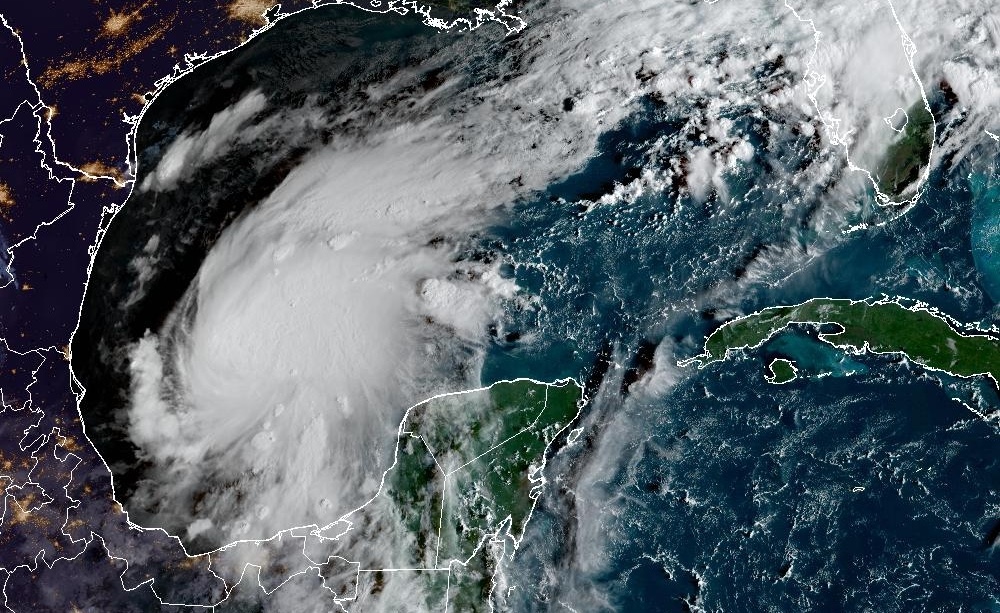
Morning update: October 8, 2026. Forecasts can change; check official alerts before making travel or safety decisions.
As Hurricane Isaias strengthens in the Gulf, residents and property managers in Aventura, Davie and Downtown Miami are asking practical questions: Is our area in the storm’s path? How much rain could fall? Could coastal water reach streets, garages or buildings?
Southeast Florida’s confirmed concerns include heavy downpours, localized flooding and minor coastal flooding associated with king tides. Isaias is forecast to approach the northern Gulf Coast, and the official sources reviewed do not establish a specific storm surge height for our three communities.
Where Is Hurricane Isaias Headed?
At 8 a.m. EDT on October 8, the National Hurricane Center reported:
- Maximum sustained winds: 80 mph.
- Movement: East-northeast at 9 mph.
- Minimum central pressure: 975 millibars.
- Location: Approximately 385 miles south-southwest of the Mississippi River’s mouth.
Northern Gulf Coast landfall was forecast for late Friday, October 9, or early Saturday, October 10. These are storm-center statistics—not predicted winds for Miami or Davie.
The Southeast Florida Forecast: Numbers That Matter
| Indicator | Verified forecast or guidance | What it means locally |
|---|---|---|
| Localized heavy rain | 2–4 inches in a short period Thursday afternoon or evening | Possible beneath stronger storms; not a total expected at every address. |
| Thursday rain chances | Miami: 60%; Fort Lauderdale: 70%; Pembroke Pines: 70% | Forecast points for regional context, not exact forecasts for every neighborhood. |
| Coastal Flood Statement | Through Friday evening, October 9 | Isolated minor flooding on low-lying coastal roads and property. |
| Miami-Dade king tide window | October 7–13 | A published high-tide period; actual impacts depend on location and weather. |
Sources: NWS Miami and Miami-Dade County. Rain probability describes the chance of precipitation, not its depth or duration.
Storm Surge and King Tides: Understand the Difference
Storm surge is seawater rising above the normally predicted tide because of a storm, primarily as winds push water toward shore. Storm tide combines that surge with the astronomical tide. King tides are especially high predicted tides that can cause coastal flooding even without a hurricane making landfall nearby.
NWS Miami attributes the current minor coastal flooding concern to king tides. Its Coastal Flood Statement covers coastal Broward, coastal Miami-Dade, far southern Miami-Dade and coastal Palm Beach counties through Friday evening. Some low-lying roads and properties may experience water.
Miami-Dade identifies October 7–13 as a king tide window, among its highest predicted tide periods this fall. The county cautions that heavy rain, strong winds and waves can worsen flooding during high tides. That overlap deserves attention even where a direct hurricane strike is not forecast.
Credit: NOAA/National Weather Service Miami. The downloadable article preserves the October 8 graphic. This is coastal-flooding guidance, not an Isaias storm surge depth map.
When Could Rain Cause Problems?
NWS Miami expects Thursday’s stronger, slow-moving storms to produce localized downpours, particularly around the east coast metropolitan corridor and areas along or north of Alligator Alley. Urban areas, poor drainage locations and already saturated ground are most susceptible.
Friday’s higher afternoon rain chances shift toward the interior and Southwest Florida. Saturday remains wet and unsettled, with breezy southeast winds and possible localized flooding. Conditions may trend drier Sunday. These are evolving forecasts, not a guarantee of flooding or dry weather at any particular property.
Credit: NOAA/National Weather Service Miami. The downloadable article preserves the October 8, 4:41 a.m. graphic. This is a daily hazard outlook, not a rainfall accumulation map.
What Should Aventura, Davie and Downtown Miami Prioritize?
Use your property’s location and flooding history to guide preparations. The following are practical priorities, not predictions that every neighborhood will flood:
- Aventura: For properties near waterways or low-lying coastal roads, review access routes and move vehicles from known flood-prone locations before water rises.
- Downtown Miami: Building managers should review procedures for garage entrances, ground-level storage, deliveries and resident communication if access roads flood.
- Davie: Focus on rainfall runoff, drainage and low-lying areas. Davie’s stormwater guidance identifies heavy-rain runoff as a local flooding concern.
Miami-Dade advises moving vehicles to higher ground ahead of king tides when possible. Davie residents can receive town alerts by texting AlertDavie to 888-777.
Prepare Before Water Reaches Your Property
Keep drains and gutters free of debris while conditions are safe. Store important documents in waterproof containers, keep essential contacts accessible and review where household members, staff or guests will go if officials order an evacuation.
Photograph important possessions before an event to help document their condition. For businesses and condominium buildings, make sure the people responsible for emergency communications can reach residents, employees and contractors.
Never drive or walk through floodwater. According to the National Weather Service:
- Six inches of moving water can knock a person off their feet.
- Twelve inches of water can float a car or small SUV.
These are danger benchmarks, not safe-depth limits. Floodwater can conceal electrical hazards, chemicals, sharp objects and missing pavement. Never drive around barricades.
If Water Enters: Safety First, Then Professional Drying
Stay out of flooded rooms where outlets or electrical cords may be submerged. Do not enter an unsafe building to take photos or retrieve belongings. Once access is safe, document damage and contact your insurer and a restoration professional.
The EPA recommends drying water-damaged areas and items within 24–48 hours to help prevent mold growth. This is a prompt-action target, not a reason to enter a hazardous area or a guarantee that every material can be saved. Moisture control also means addressing the source of the water.
Local Water Damage Restoration Support
PuroClean of Aventura, Davie & Downtown Miami provides emergency property restoration support, including water damage restoration and mold remediation. Our team can help assess affected areas and plan the cleanup and drying work your property needs.
For 24/7 emergency restoration assistance, call (305) 907-7373. For immediate danger or rescue, call 911. Response and access must follow safe conditions and official restrictions.
Stay informed, prepare early and put people first. Follow NWS Miami and the National Hurricane Center for updated forecasts.